DELTA Grant Enhances Student Learning
Team Applies Technologies to Visualize and Model River Processes
Higher-level courses in the Marine, Earth, and Atmospheric Sciences (MEAS) department often require detailed and measured observations. Thus, when Associate Professors Karl Wegmann and Ethan Hyland received a DELTA Grant to enhance student learning with the MEAS geosystem stream table, they understood the educational value a tactile experience could provide students and the potential of incorporating more advanced technologies.
“It’s impossible to show students the evolution of a landscape first hand or allow them to make quantitative measurements of erosion rates in the field,” Hyland said. “So developing digital technologies for the experimental stream table in our department allows students (even those attending virtually) to really see and experience things like a flash flood or delta migration up close.”
To meet the needs for the program, a team of DELTA specialists were challenged to digitally capture stream table observations for both MEA 450: Sedimentology and Stratigraphy and MEA 481: Geomorphology, courses where students use the stream table to gather data about landscape evolution and depositional environments. The broad premise of this grant was to develop materials and activities that supported stream table observation as well as experimental uses of stream tables for educational and research purposes.
The following DELTA team members were involved in this grant experience:
- Arthur Earnest, instructional media producer
- David Tredwell, interaction designer and developer
- Stephen Waddell, immersive media developer
- Bethanne Winzeler, instructional designer
Understanding the Goals
A stream table demonstrates the dynamic nature of water flow within a watershed and provides a physical model of how water behaves. As the water flow changes, the stream table can simulate effects on the landscape caused by erosion or deposition of sediment using different variables, such as the speed of water flow or the slope and topography of the land.
The courses associated with this project were in person, so the team employed techniques that treated the project more as an interactive exhibit design. Essentially, the team was enhancing the capabilities of the stream table through media for interactive learning and exploration with the stream table as the central piece of their technology.
One of the goals was to create a video that showed how to use the technology of the table itself. Using GoPros attached to the ceiling, the team captured time lapses of the table in action. Basic concepts about stream and delta systems that in the real world might take decades to hundreds of years to evolve come to life in the analog stream table model in minutes to hours.
In thinking about the more interactive elements of the project, the team had to address a number of challenges, including finding the proper media equipment for capturing the necessary images and dealing with the small space of the room where the stream table was housed. The team wanted to deliver an accurate and complete picture of the table in any format that would be helpful for archiving different configurations.
“We tried a number of 3D capture cameras and worked through issues with reflectivity of the sand and water to find the best options for getting a good 3D view of the table,” Waddell said.
“To capture color and depth data in real-time to do different types of visualizations, we needed to find the best-fit software as well,” Tredwell said. “We went with a program called TouchDesigner, which is frequently used for video DJing and interactive art installations. In this project, it allowed us to live video – 2D and 3D – and transform it into different forms, such as topographical maps.”
For the final product, QR codes are now in place throughout the room and on the table that, when scanned, lead the user to the orientation video.
Addressing Challenges
When addressing issues with the lab space, the team wanted to surround the stream table with the needed technology, but the space was extremely tight. Due to time and facility constraints, the team needed a custom, free-standing structure that did not modify the room in any way.
“We designed a system in Blender so that we knew exactly where devices needed to be mounted in relation to the stream table,” Tredwell said. “This way, we could spec out and design a simple scaffolding system ahead of time and then assemble it in the lab – in about 20 elevator trips!”
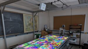
The final design was a structure that hugged the outside of the room, while still providing students with full access to the stream table. In addition, the structure was sturdy enough to suspend a projector and multiple cameras pointed at the surface of the table while connected to a PC in the corner of the room.
The team also created a simple web interface to work with all the behind-the-scenes devices and software, allowing users to capture images, recordings and time lapses of the stream table on the fly.
“We provided instructors with an uploaded image based on a Google slide template,” Tredwell said. “Using this template, instructors can sketch out guidance and details for how to carve channels and can then project that information on top of the stream table to ensure that users start with the same conditions to replicate an experiment as needed.”
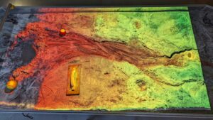
The team designed a means to project a height visualization to emphasize where peaks and channels were. Additionally, instructors can finely control the spectrum of colors used, for example using a variation of colors to show how the terrain had changed over time.
One realization the team had was that not all visualizations needed to be complex. One of the simplest but most useful visualizations is a grid reference, which is a simple overlay grid with adjustable color to help students gauge distances and movement.
Reaching Beyond the Goals
The team is optimistic that in the future this technology can be helpful for instructors beyond the immediate uses for this particular project, for example when working with students in virtual situations for online learning and providing more accessibility to the stream table.
“One of the more experimental features we’ve considered is where instructors can use the overhead webcam to host Zoom sessions with the stream table and turn on a feature called ‘reprojection,’ which uses the Zoom feed and displays it back on the stream table,” Tredwell said. “This method allows for Zoom annotations to show up on the stream table for everyone, online or in-person.”
In addition, other possibilities for expansion include converting point cloud capture data into terrain that students can navigate at full scale, through virtual reality (VR) or by 3D printing landscapes to aid visually impaired students. The team also hopes to further integrate with Esri’s ArcGIS so that instructors can then use the data to analyze terrain and import files generated on the stream table for the same kinds of exercises they would run on data from real world terrain.
“Ethan and I had a general sense of the technological improvements we wanted to implement in the stream table lab, but we needed to figure out how to get there,” Wegmann said. “The DELTA team was instrumental in the creative process as well as the design and implementation of new technologies and solutions to expand the educational reach of the MEAS department’s stream model.”
“This truly was an exploratory process,” Earnest said. “The DELTA Grant team considered and investigated new avenues, from state of the art computing and visualization to designing a more interactive room. The final results represent a great team effort!”
Want information about how to collaborate with DELTA to develop instructional technologies for your course? Learn more about the grant cycle and how to apply for a DELTA Grant.
This post was originally published in DELTA News.
